RARE COLLECTION OF 18 TACTILE BLIND MAPS FROM WORLD WAR II - TOPOGRAPHICAL
Slutar 7 jan 2026 18:49
7 500 kr
7 877 kr med köparskydd.
Fraktpris inom Sverige
250 kr Annat fraktsättSäljaren erbjuder ett alternativt fraktsätt. Vänligen se objektsbeskrivningen för mer info.
Kan hämtas i
Alla betalningar granskas av Tradera för din säkerhet.


Direktbetalning
Köparskyddet gäller alla betalsätt
1/0
Beskrivning
LOTS MORE PHOTOS ON REQUEST!!
Marburger Blindenstudieanstalt 1940-1949.
Description
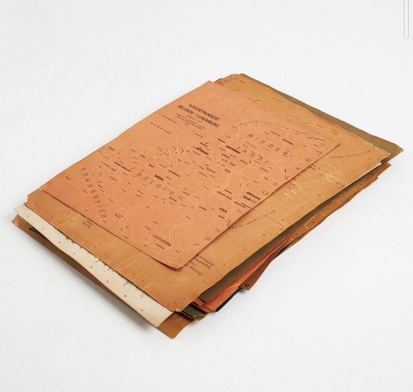
The collection consists of: 10 printed tactile maps., printed at Lehrmittelverlag der Marburger Blindenstudieanstalt by WJ Becker, 1940–1949. + 8 tactile maps without printed text (but most likely printed at Lehrmittelverlag der Marburger Blindenstudieanstalt). One of those with a movable circle.
All 18 maps printed on embossed brownish-red or beige cardboard. Measurements vary, c: 50.5 × 36.5 cm–46.5 cm × 64.5 cm.
All maps comprised in this lot were produced and used by the Marburger Blindenstudienanstalt (today Die Deutsche Blindenstudienanstalt in Marburg) which is an educational institution for blind and visually impaired people. The institution was founded in 1916 as a result of World War I where many young men returned home with visual impairments or total blindness.
The maps mark out geographical features and include braille inscriptions and were made for the blind and partially sighted. They depict various places in the world, including several parts of Germany, Great Britain, Africa and Canada together with the USA. Two of the maps in this lot are dated to the time during WWII.
The collection includes, among others: Great Britain and Ireland, 1940; Great Britain and Ireland, 1940; Beikarte zur Umgebungskarte, 1947; Das Relief Mitteleuropas, Teil 1: Nordseeküstengebiet, 1948; Das Relief Mitteleuropas, Teil 2: Ostseeküstengebiet, 1948; Das Relief Mitteleuropas, Teil 3: Mitteldeutsches Gebirgsland, 1948; Das Relief Mitteleuropas, Teil 4: Böhmer Becken und Randgebiete, 1948; Das Relief Mitteleuropas, Teil 5: Süddeutschland, 1949; Niederlande Belgium-Luxembourg, 1949; CANADA / USA Side map Eastern part of the United States.
18 maps in total.
Condition
Mostly in fine condition, the margins slightly browned, some corners broken or worn, some slight spotting. 1 stamped Marburg, some slight notes in ink.
Mer från säljaren
- Sluttid17 dec 16:53.Pris:950 kr,Köp nu.
- Sluttid17 dec 16:53.Pris:6 995 kr,Köp nu.
- Sluttid17 dec 16:53.Pris:24 995 kr,Köp nu.
- Sluttid19 dec 20:33.Pris:5 450 kr,Utropspris.
- Sluttid20 dec 20:29.Pris:1 750 kr,Utropspris.
- Sluttid20 dec 21:02.Pris:2 450 kr,Ledande bud.
- Sluttid22 dec 19:00.Pris:1 495 kr,Utropspris.
- Sluttid25 dec 20:24.Pris:2 995 kr,Köp nu.
- Sluttid26 dec 22:24.Pris:595 kr,Köp nu.
- Sluttid26 dec 22:24.Pris:4 950 kr,Köp nu.
- Sluttid26 dec 22:24.Pris:3 995 kr,Köp nu.
- Sluttid30 dec 10:48.Pris:24 950 kr,Köp nu.
- Sluttid31 dec 15:06.Pris:995 kr,Köp nu.
- Sluttid31 dec 15:06.Pris:3 500 kr,Köp nu.
- Sluttid2 jan 18:20.Pris:1 495 kr,Köp nu.
- Sluttid7 jan 19:07.Pris:2 495 kr,Köp nu.
- Sluttid9 jan 19:32.Pris:1 150 kr,Köp nu.
- Sluttid12 jan 12:33.Pris:4 500 kr,Köp nu.
- Sluttid12 jan 12:34.Pris:5 500 kr,Köp nu.
Andra har även tittat på
Mer för dig
Pris:.
Pris:.
Pris:.
Pris:.
Pris:.
Pris:.
Pris:.
Pris:.
Pris:.
Pris:.
Pris:.
Pris:.

